| Origins | |
| 01- | Introduction |
| The Dog | |
| 02- | Part I |
| 03- | Part II |
| 04- | Part III |
| The Monkey | |
| 05- | Part I |
| 06- | Part II |
| 07- | Part III |
| 08- | Part IV |
| 09- | Part V |
| 10- | Part VI |
| 11- | Part VII |
| The Dragon | |
| 12- | Part I |
| 13- | Part II |
| 14- | Part III |
| 15- | Part IV |
| 16- | Part V |
| 17- | Part VI |
| 18- | Part VII |
| 19- | Part VIII |
| UR / Drexciya / D1 | |
| 20- | Part I |
| 21- | Part II |
| 22- | Part III |
| Pangea | |
| 23- | Part I |
| 24- | Part II |
| 25- | Part III |
| 26- | Part IV |
| 27- | Part V |
| 28- | Part VI |
| 29- | Part VII |
| 30- | Part VIII |
| 31- | Part IX |
| 32- | Part X |
| 33- | Part XI |
|
||||
 |
||||
|
||||
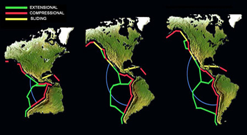
| Having entered into unknown territory I decided to avail of my ignorance in the face of such a large topic and I decided to simply glance at the Earth as if I had never seen it before - I suppose to try to find some kind of 'key' that may reveal itself to a fresh eye. I looked simply for the coastlines that were the most similar. I found that, in contrast to the obvious coasts of Africa and South America, what jumped out to me was that the West coastlines of North and South America appeared to be inverted images of each other. I thought 'That's the key! - close North and South America back onto itself and it pulls everything around in behind it - effectively closing the Ring Of Fire'. That's the significance of the Ring of Fire and Central America is the 'key'!' It was 6:00 am at this stage and it was still too early to find anywhere to go online or to call someone ( friends that I knew had studied geology ). So, with a few hours to kill, I sifted through my bookshelf. I found a pocket dictionary of geography that I had picked up somewhere along the way in my travels, probably in Asia, as the world maps centered on the Pacific. In this book there were basic maps of the fault lines and plates of the sea-beds and the areas of volcanic activity. I found that the positioning of extensional and compressional fault lines in Central America supported my idea of closing North and South America, the configuration of the three plates of Central America acting like a hinge. |
||||